We use cookies for your personalized browsing experience, to personalize content and ads, to provide social media features, and to analyze traffic to our website. We also share information about your use of our website with our social media, advertising and analytics partners. Our partners may combine this information with other data that you have provided to them or that they have collected as part of your use of the Services. (incl. US providers)

Start Point

Nature Park Information Center Scharnitz

End Point

Nature Park Information Center Scharnitz

Difficulty

Medium

Total Distance

42,00 km

Descent Meters

1396 m

Highest Point

2321 m

Total Time

09:00 h

Map & Elevation Profile

Start Point

Nature Park Information Center Scharnitz

End Point

Nature Park Information Center Scharnitz

Difficulty

Medium

Total Distance

42,00 km

Descent Meters

1396 m

Highest Point

2321 m

Total Time

09:00 h

Hiking

Best Time

Jan

Feb

Mar

Apr

May

Jun

Jul

Aug

Sep

Oct

Nov

Dec

Hiking tour

Bike & Hike

+1

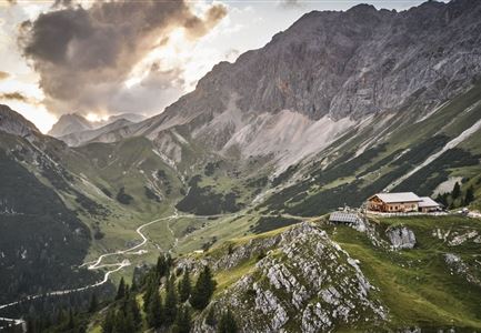
Route: Information centre Scharnitz – Gleirschhöhe – Valley Hinterautal – Source of the River Isar – Alpine Hut

Kastenalm – Lafatscher Niederleger – Alpine Hut Hallerangeralm– Alpine House Hallerangerhaus – Alpine Hut Hallerangeralm – Lafatscher Niederleger – Alpine Hut Kastenalm – Source of the River Isar – Valley Hinterautal – Gleirschhöhe – Information centre Scharnitz

Directions:

Very long hike, which requires good physical fitness. To save time, it is recommended to take the bike up to Kastenalm and then continue on foot to the Hallerangeralm.

Starting at the information centre Scharnitz at car parking Länd follow the road towards the Isarlodge Wiesenhof. Continue on to Gleirschhöhe where you take the forest track to your left towards the source of the river Isar. Just before the Kastenalm park your bike and cross over a little bridge.Then go up a steep track past the Lafatscher Niederleger to mountain meadows Halleranger. When you reach the pastures the path splits, left to the hut Hallerangeralm. To the left below the alpine pasture, a small, marked trail branches off and leads diagonally upwards across the alpine pasture into a mountain pine alley. The mountain pines clear after a few hairpin bends and the trail continues across

Read More...

Features & Characteristics

Start Point

Nature Park Information Center Scharnitz

End Point

Nature Park Information Center Scharnitz

Similar Tour Suggestions

Fischerrei am Weidachsee - Leutasch

Hiking

Circular walk around Weidachsee lake

Length

3,80 km

Duration

01:00 h

Uphill

46 hm

Altitude

1156 hm

Difficulty

Easy

Wegmarkierung

Hiking

Mountain tour crossing of the Arnspitzen

Length

11,50 km

Duration

08:30 h

Uphill

1353 hm

Altitude

2196 hm

Difficulty

Hard

Scharnitz_Gießenbach_Eppzirl.jpg

Hiking

Circular village walk Scharnitz - Gießenbach

Length

6,10 km

Duration

01:30 h

Uphill

42 hm

Altitude

1013 hm

Difficulty

Easy

Wanderweg führt an der Gleirschklamm entlang.jpg

Hiking

Circular hiking trail Gleirschklamm

Length

13,10 km

Duration

04:00 h

Uphill

381 hm

Altitude

1152 hm

Difficulty

Medium

Seefeld Reith 2022 Sommer Wanderung Noerdlinger Huette Reither Spitze Seefelder Spitze Seefelder Joch Panorama Hochplateau

Hiking

Circular hike to the Nördlinger Hütte alpine hut & Reither Spitze Summit, 2,374m

Length

9,10 km

Duration

07:30 h

Uphill

1161 hm

Altitude

2374 hm

Difficulty

Hard

Muggenmoosalm

Hiking

Circular hike from Seefeld to the Lottenseehütte alpine hut & Muggenmoosalm alpine hut

Length

15,30 km

Duration

04:30 h

Uphill

554 hm

Altitude

1398 hm

Difficulty

Easy

Brunschkopf

Hiking

Brunschkopf viewing platform via Wildmoosalm from Leutasch

Length

12,70 km

Duration

04:30 h

Uphill

447 hm

Altitude

1486 hm

Difficulty

Medium

Runst_Leutasch

Hiking

Circular walk Höhenweg - Runst

Length

7,40 km

Duration

02:00 h

Uphill

128 hm

Altitude

1156 hm

Difficulty

Easy