Start Point

Citizen and tourism service Reith

End Point

Citizen and tourism service Reith

Difficulty

Easy

Total Distance

4,57 km

Descent Meters

113 m

Ascent Meters

113 m

Highest Point

1126 m

Total Time

01:30 h

Map & Elevation Profile

Start Point

Citizen and tourism service Reith

End Point

Citizen and tourism service Reith

Difficulty

Easy

Total Distance

4,57 km

Descent Meters

113 m

Ascent Meters

113 m

Highest Point

1126 m

Total Time

01:30 h

Hiking

Best Time

Jan

Feb

Mar

Apr

May

Jun

Jul

Aug

Sep

Oct

Nov

Dec

Hiking tour

Thematic route

+4

The educational culture trail between Reith and Leithen can also be walked in winter and leads along ten different historical monuments and sites through the countryside and history along the old roman road.

Station 1: Citizen and Tourism Service Reith
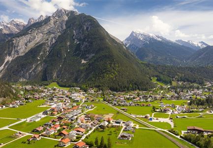
The Karwendelbahn railway was built according to the plans of the Innsbruck architect Josef Riehl and is still considered a masterpiece of engineering at that time because of the magnificent bridge and tunnel constructions. Our village is situated in an unmistakable environment on the so-called "Sunnroan" (sunny slope). Enjoy the wonderful view over the Inn valley.

Station 2: Music pavilion
From 1914 to 1918 all able-bodied men had to go to the front. 13 Reither did not return home from the 1st World War. During the 2nd World War (1939-1945) 15 from our community were killed in action. The end of the war is connected with the complete destruction of the village. There were flown 6 heavy bombing raids on our village to destroy the railroad bridge over the Gurgelbach.

Station 3: Sunnroanweg
22. houses were totally destroyed, another 12 houses as well as the church and school were severely damaged. Only after the reconstruction the appearance of the village underwent significant changes, as also some resettlements from the

Read More...

Features & Characteristics

Start Point

Citizen and tourism service Reith

End Point

Citizen and tourism service Reith

Family-friendly

Yes

Loop tour

Yes

Similar Tour Suggestions

Familien-Weitwanderung im Gaistal - Familie steht auf Terasse bei der Wettersteinhütte - Vater zeigt auf etwas.jpg

Hiking

Stage 1: To Wettersteinhütte or Wangalm – Leutasch 3-Day Hut Hike for Families

Length

4,70 km

Uphill

550 hm

Altitude

1716 hm

Difficulty

Medium

Leutascher Geisterklamm mit Blick Richtung Mittenwald.jpg

Hiking

Long Gorge Trail through the Leutasch Spirit Gorge with Themed Trail

Length

3,20 km

Duration

01:30 h

Uphill

129 hm

Downhill

127 hm

Altitude

1060 hm

Difficulty

Medium

Hallerangeralm

Hiking

Bike & Hike Sunntigerspitze Summit, 2,321 m

Length

42,00 km

Duration

09:00 h

Uphill

1396 hm

Altitude

2321 hm

Difficulty

Medium

Muggenmoosalm

Hiking

Circular hike from Seefeld to the Lottenseehütte alpine hut & Muggenmoosalm alpine hut

Length

15,30 km

Duration

04:30 h

Uphill

554 hm

Altitude

1398 hm

Difficulty

Medium

Wanderer auf dem Weg vom Seefelder Joch zur Seefelder Spitze - Gipfelkreuz der Spitze im Blick.jpg

Hiking

"Königstour" The royal's hiking tour

Length

4,40 km

Duration

03:00 h

Uphill

502 hm

Downhill

464 hm

Altitude

2364 hm

Difficulty

Hard

Fischerrei am Weidachsee - Leutasch

Hiking

Circular walk around Weidachsee lake

Length

3,80 km

Duration

01:00 h

Uphill

46 hm

Altitude

1156 hm

Difficulty

Easy

Grosse Arnspitze Blick ins Karwendel - Scharnitz

Hiking

Hike Hoher Sattel - Große Arnspitze Summit, 2,196 m

Length

10,30 km

Duration

08:00 h

Uphill

1313 hm

Altitude

2196 hm

Difficulty

Hard

Wanderweg zur Hohen Fluder mit Blick Richtung Hohe Munde.jpg

Hiking

Hike Hoher Sattel

Length

10,60 km

Duration

04:00 h

Uphill

524 hm

Altitude

1620 hm

Difficulty

Medium