Start Point

Leutasch parking Stupfer (P2)

End Point

Leutasch parking Stupfer (P2)

Difficulty

Hard

Total Distance

21,00 km

Descent Meters

1150 m

Ascent Meters

1150 m

Highest Point

2367 m

Total Time

07:00 h

Map & Elevation Profile

Start Point

Leutasch parking Stupfer (P2)

End Point

Leutasch parking Stupfer (P2)
Difficulty

Hard

Total Distance

21,00 km

Descent Meters

1150 m

Ascent Meters

1150 m

Highest Point

2367 m

Total Time

07:00 h

Hiking

Best Time

Jan

Feb

Mar

Apr

May

Jun

Jul

Aug

Sep

Oct

Nov

Dec

Hiking tour

Bike & Hike

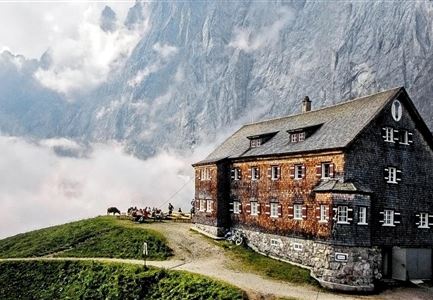
The starting point for this bike & hike tour is the parking Stupfer (P2) in Gaistal. Here, however, you do not follow the path into the valley, but the asphalt road back to Klamm. At the "Infopoint" turn north and follow the road - keep left on the upcoming intersection until you reach a frost road (gravel). From now on it goes constantly steep uphill. The beauty of the route is the dense forest with shady trees and many nice resting places. The forest road is easy to ride and winds uphill in several curves bends, but also long, almost flat sections. Above the tree line, about 100 hm below the Wettersteinhütte and the Wangalm, you should leave your bikes and tackle the last section on foot.

For those who want a sneak peek, here are two videos:


From here the path becomes very steep and rough gravel. After 10 minutes of walking you reach a cross: On the right is the Wangalm, on the left the Wettersteinhütte. Both destinations offer fantastic panoramic view. The huts are south-facing, so that in good weather you can enjoy the sun all day. Attention grazing cattle, please keep your

Features & Characteristics

Start Point

Leutasch parking Stupfer (P2)

End Point

Leutasch parking Stupfer (P2)
Similar Tour Suggestions

Gipfel Grosse Arnspitze - Scharnitz.jpg

Hiking

Hike to the Große Arnspitze Summit, 2,196 m

Length

9,00 km

Duration

07:30 h

Uphill

1247 hm

Altitude

2196 hm

Difficulty

Hard

Gravelbike - Zum Isarursprung.jpg

Hiking

Bike & Hike Speckkarspitze, 2,621 m

Length

44,00 km

Duration

11:00 h

Uphill

1794 hm

Altitude

2621 hm

Difficulty

Hard

Nördlinger Hütte - Wanderer kurz vor der Hütte (2).jpg

Hiking

Circular hike to the Nördlinger Hütte alpine hut & Reither Spitze Summit, 2,374m

Length

9,90 km

Duration

07:30 h

Uphill

1191 hm

Altitude

2374 hm

Difficulty

Hard

Falkenhütte neu

Hiking

Karwendelmarsch 52 km

Length

52,00 km

Duration

19:00 h

Uphill

2281 hm

Downhill

2217 hm

Altitude

1903 hm

Difficulty

Hard

Grosse Arnspitze Blick ins Karwendel - Scharnitz.jpg

Hiking

Hike Hoher Sattel - Große Arnspitze Summit, 2,196 m

Length

10,30 km

Duration

08:00 h

Uphill

1313 hm

Altitude

2196 hm

Difficulty

Hard

Blick auf Arnspitzen Ueberschreitung - Scharnitz.jpg

Hiking

Mountain tour crossing of the Arnspitzen

Length

11,50 km

Duration

08:30 h

Uphill

1353 hm

Altitude

2196 hm

Difficulty

Hard

Wanderer auf der Seefelder Spitze ueber Seefeld.jpg

Hiking

Bike & Hike Seefelder Spitze Summit, 2,220 m

Length

13,00 km

Duration

04:30 h

Uphill

1094 hm

Altitude

2220 hm

Difficulty

Hard

Wanderer auf dem Weg vom Seefelder Joch zur Seefelder Spitze - Gipfelkreuz der Spitze im Blick.jpg

Hiking

"Königstour" The royal's hiking tour

Length

4,40 km

Duration

03:00 h

Uphill

502 hm

Downhill

464 hm

Altitude

2364 hm

Difficulty

Hard