We use cookies for your personalized browsing experience, to personalize content and ads, to provide social media features, and to analyze traffic to our website. We also share information about your use of our website with our social media, advertising and analytics partners. Our partners may combine this information with other data that you have provided to them or that they have collected as part of your use of the Services. (incl. US providers)

Start Point

Scharnitz information centre (parking Länd P2)

End Point

Scharnitz information centre (parking Länd P2)

Difficulty

Medium

Total Distance

36,00 km

Descent Meters

839 m

Ascent Meters

839 m

Highest Point

1765 m

Total Time

11:15 h

Map & Elevation Profile

Start Point

Scharnitz information centre (parking Länd P2)

End Point

Scharnitz information centre (parking Länd P2)

Difficulty

Medium

Total Distance

36,00 km

Descent Meters

839 m

Ascent Meters

839 m

Highest Point

1765 m

Total Time

11:15 h

Hiking

Best Time

Jan

Feb

Mar

Apr

May

Jun

Jul

Aug

Sep

Oct

Nov

Dec

Hiking tour

Hut hikes

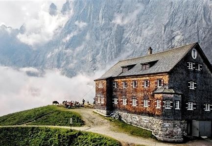
Route: Scharnitz Nature Park Info Center - Karwendel Valley - Hochalm - Karwendelhaus

Very long hike that requires good physical condition.

Parking and public transport:

P2 "Karwendelparkplatz Länd".

By train to Scharnitz station (10 minutes walk to the starting point).

You can find all connections in real time with the Mobility-App "wegfinder".

Directions:

The starting point is at the Scharnitz Nature Park Info Center. First follow the Hinterautalstraße in the direction of the Karwendel valleys. After about 500 m you will cross the Isar river. After the bridge, turn left, walk uphill for about 50 m, turn right at the junction into the Karwendel valley and keep following the forest road. If you have time and feel like it, you can make a short detour to the Birzlkapelle, a small chapel in the forest (about 5 min. from the turnoff to the chapel). Equally worthwhile is a detour to the Karwendelsteg (about 10-15 min. from the turnoff) with a view of the impressive waterfall of the Karwendelbach. The last part of the trail is a somewhat steeper ascent in wide serpentines, past the Hochalm (not managed), until you reach the Karwendelhaus

Read More...

Features & Characteristics

Start Point

Scharnitz information centre (parking Länd P2)

End Point

Scharnitz information centre (parking Länd P2)

Similar Tour Suggestions

Kneippen nahe der Scharnitzer Alm

Hiking

Circular hiking trail Scharnitzer alpine hut

Length

5,70 km

Duration

01:30 h

Uphill

130 hm

Altitude

1022 hm

Difficulty

Easy

Pleisenhütte Sommer

Hiking

Hike to the Pleisen alpine hut

Length

15,90 km

Duration

05:00 h

Uphill

780 hm

Downhill

776 hm

Altitude

1753 hm

Difficulty

Medium

hochleithenkopf.jpg

Hiking

Hike to the Hochleithenkopf

Length

8,20 km

Duration

02:30 h

Uphill

200 hm

Altitude

1187 hm

Difficulty

Easy

Bodenalm Stall mit Brunnen

Hiking

Circular hiking traill to the Bodenalm alpine hut

Length

8,40 km

Duration

02:30 h

Uphill

180 hm

Altitude

1198 hm

Difficulty

Easy

Ahrn Hochfluder Weidach.jpg

Hiking

Hike Hoher Sattel

Length

10,60 km

Duration

04:00 h

Uphill

524 hm

Altitude

1620 hm

Difficulty

Medium

Pfarrhuegel in Seefeld.jpg

Hiking

Village tour lake Wildsee via Pfarrhügel

Length

3,20 km

Duration

01:00 h

Uphill

23 hm

Altitude

1203 hm

Difficulty

Easy

Nach Gießenbach und Scharnitz.jpg

Hiking

Hike from Seefeld to Scharnitz

Length

9,60 km

Duration

02:30 h

Uphill

27 hm

Downhill

288 hm

Altitude

1252 hm

Difficulty

Easy

Brunschkopf während der Goldenen Stunde.jpg

Hiking

Viewpoint Brunschkopf via forest road

Length

9,00 km

Duration

03:00 h

Uphill

284 hm

Altitude

1496 hm

Difficulty

Medium