Hiking and Biking to the Source of the River Isar
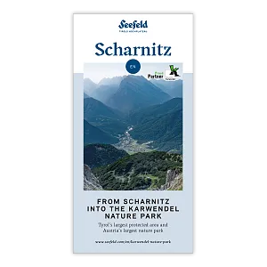
The Source of the River Isar in the Karwendel Nature Park
The source of the river Isar – one of Bavaria’s most famous rivers – lies in the Hinterautal Valley near Scharnitz, in the heart of the Karwendel Nature Park at 1,162 meters above sea level. Here, crystal-clear spring water bubbles up from three natural springs in a peaceful, untouched spot at the foot of impressive Karwendel peaks. Locals affectionately call this place “Bei den Flüssen” (At the Rivers).
This is where a remarkable journey begins: From its source in Tyrol to its mouth at the Black Sea, the river’s path spans around 30 days. Each drop of water takes about 30 hours to reach the Danube. For the first 15 kilometers, the river flows through Tyrol before crossing into Bavaria via Scharnitz.
It can take up to 15 years for rain or melted snow to seep through the rock layers and become enriched with valuable minerals before emerging at the spring. After just a few meters, the small streams merge into a strong brook – the young Isar – winding its way through the scenic Hinterautal Valley.
A hike or bike tour to the source of the river Isar is one of the most popular nature experiences in the Karwendel Nature Park. Whether on foot or by mountain bike, the route offers stunning alpine scenery, clear waters, and peaceful surroundings. A short distance further, the rustic Kastenalm invites you to take a break and enjoy a traditional snack, nestled among majestic maple trees.
Today & Coming Days: Visitor Forecast

Dull throughout the day with light snowfall every once in a while.
Loading data...
2026-01-10
max
-1 °C
min
-6 °C
Loading data...
2026-01-11

max
-5 °C
min
-14 °C
Loading data...
2026-01-12

max
2 °C
min
-14 °C
Important Information
- The route to the source of the river Isar is not technically difficult, but it is long. Good basic fitness and endurance are essential for both hiking and biking tours.
- The source of the river Isar lies in a protected natural area.Please do not leave any rubbish behind and respect the flora and fauna.
- We recommend travelling to Scharnitz railway station by public transport. Your guest card is valid as a ticket for all public bus connections in the region, including the train journey between Seefeld and Scharnitz.
- From Scharnitz train station, it is only a 10-minute walk to the starting point at the Scharnitz Nature Park Information Centre.
Paths of Discovery
Routes & Tours to the Source of the River Isar


Taxi Rides into the Valleys and Boat Transport into Hinterautal
From 1ˢᵗ June to 15ᵗʰ October every year
• Taxi and Minibus Mair – Scharnitz T. +43 5213 5363
• Taxi Ramona – Giessenbach T. +43 5213 5541
Please contact the companies directly for information about rates and availability.
Note for Karwendel Valley and Eppzirl: Transfers are only allowed on weekdays and are limited to a maximum of 4 trips per day. No transfers are permitted on weekends and public holidays.


Arrival & mobility
Arriving in Scharnitz by Public Transport
You can get to Scharnitz by bus or train from Innsbruck (check connections here with Scotty) or from Germany (check here with Deutsche Bahn).
From the train station in Scharnitz, it's just a 10-minute walk to the starting point at the Nature Park Info Center.
Good to know: Your guest card is also your ticket for all public buses in the region during your stay. It also includes train rides between Seefeld and Scharnitz.
Parking facilities
For hikers, we recommend the large P2 “Karwendelparkplatz Länd”, located directly at the Nature Park Information Centre in Scharnitz.
For cyclists, the P1 “Riedboden” car park (if arriving from Munich) and the P4 “Mühlberg” car park (if arriving from Innsbruck) are ideal options. From there, it’s about a 5-minute ride to the Nature Park Information Centre.


Code of Conduct
Your safety and the protection of our unique nature are very important to us. Please enjoy this beautiful landscape with respect. By following these ten simple rules, you actively contribute to preserving this natural paradise.
Commercial filming and photography in the Karwendel Nature Park are becoming increasingly popular. However, due to the area's special protected status, official permission and compliance with specific rules are required. Detailed information on how to apply for a filming or photography permit can be found on this page.
Please also follow the general rules of conduct for the Karwendel Nature Park.
Important information for mountain bikers can be found here.