Address & Contact

Parkplatz Zentrum (P8, mit Elektrotankstelle)

Town:

Münchner Straße 445, 6100 Seefeld

Phone:

Parking lot & parking garage

Designated disabled parking space

Electric charging station

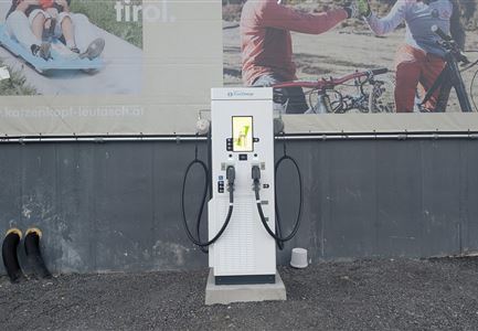
Directly at the roundabout on Münchner Straße, not far from Seefeld train station, there is a large parking area with two green-marked e-parking spaces and a TIWAG charging station. During the summer months, the two charging spots are pleasantly shaded in the afternoon on the north facade of the Reither Brot branch. At parking lot P8, there is a barrier-free toilet and 2 designated disabled parking spaces.

The specially developed e-mobility app from TIWAG works at all designated TIWAG charging stations, simplifies login and charging process, offers special charging rates, and is available for iOS and Android.

iOS https://apps.apple.com/at/app/tiwag-e-mobility-app/id1236700761
Android https://play.google.com/store/apps/details?id=com.beenergised.chargemobile.tiwag

Fees (Monday to Sunday, 8:00 AM – 8:00 PM):
€ 1,- for 1 hour, € 2,- for 2 hours, € 3,- for 3 hours, € 4,- for 4 hours, € 5,- for 5 hours, € 6,- for 6 hours, € 8,- for the whole day.

Parking tickets in Seefeld can be easily paid via app - The municipality of Seefeld now offers parking with the EasyPark app as an alternative to purchasing a ticket at the parking meter.

Fire Brigade Parking East (Area at the very top): Stopping and parking prohibited (excluding commuters), year-round
Connected Tours

Verbindung-Seefeld-Reith Pfarrhügel (c) Anna Rieder

Cycling

Bike-Verbindung Nr. 5030 Seefeld-Reith

Length

10,20 km

Duration

00:35 h

Uphill

120 hm

Downhill

115 hm

Altitude

1193 hm

Difficulty

Easy

Trailrunning in der Region Seefeld - Läuferinnen in Seefeld - Fußgängerzone.jpg

Running

Dorflaufrunde Seefeld

Length

4,90 km

Duration

01:00 h

Uphill

22 hm

Altitude

1207 hm

Difficulty

Easy

Bodenalm im Sommer (4).jpg

Hiking

Rundwanderung zur Bodenalm und Triendlsäge

Length

8,40 km

Duration

02:30 h

Uphill

180 hm

Altitude

1198 hm

Difficulty

Easy

Wildmoosalm im Sommer - Hütte mit Kuh.jpg

Hiking

Wanderung zur Wildmoosalm

Length

5,80 km

Duration

01:45 h

Uphill

131 hm

Altitude

1305 hm

Difficulty

Easy

Wildsee im Herbst - Drohnenaufnahme - Blick auf Golfplatz und See mit Bergpanorama.jpg

Hiking

Rundwanderung von Seefeld nach Auland & Reith

Length

9,30 km

Duration

02:45 h

Uphill

139 hm

Downhill

141 hm

Altitude

1199 hm

Difficulty

Easy

Trailrunning in der Region Seefeld - Trail durch den Wald.jpg

Running

Trailrun-Runde um den Hochleithenkopf

Length

16,50 km

Duration

06:00 h

Uphill

760 hm

Altitude

1249 hm

Difficulty

Easy

Möserer See im Frühling - Paar läuft entlang des Seeweges.jpg

Hiking

Rundwanderung von Seefeld zum Möserer See

Length

8,80 km

Duration

02:30 h

Uphill

231 hm

Altitude

1297 hm

Difficulty

Easy

Brunschkopf im Frühwinter bei Sonnenaufgang_Drohnenaufnahme reingezoomt auf Plattform.jpg

Hiking

Schneeschuhwanderung: Weg Nr. S1: Brunschkopf

Length

5,00 km

Duration

02:00 h

Uphill

189 hm

Downhill

287 hm

Altitude

1497 hm

Difficulty

Medium

Gravelbiker in Scharnitz im Sommer

Cycling

Bike-Verbindung Nr. 5051 Seefeld-Scharnitz

Length

25,30 km

Duration

01:15 h

Uphill

256 hm

Downhill

250 hm

Altitude

1195 hm

Difficulty

Medium

Wildmoos (c) Anna Rieder

Cycling

Biketour Nr. 5069 Seefeld-Wildmoos

Length

6,30 km

Duration

00:30 h

Uphill

122 hm

Downhill

120 hm

Altitude

1308 hm

Difficulty

Medium

Trailrunning auf der Seefelder Spitze - Läufer mit Blick auf das Plateau im Hintergrund.jpg

Running

Trailrun-Runde über Nördlinger Hütte & Eppzirler Alm nach Seefeld

Length

25,80 km

Duration

10:00 h

Uphill

1320 hm

Altitude

2243 hm

Difficulty

Hard

Wildmoosalm im Sommer - Hütte mit Kuh.jpg

Cycling

Gravelbiketour Wildmoos

Length

20,00 km

Duration

03:15 h

Uphill

450 hm

Altitude

1510 hm

Difficulty

Medium

Gravelbiker auf der Strasse zwischen Seefeld und Leutasch -Abfahrt

Cycling

Bike-Verbindung Nr. 5052 Seefeld-Leutasch

Length

15,00 km

Duration

00:45 h

Uphill

271 hm

Altitude

1221 hm

Difficulty

Medium

Radfahrerin beim Sonnenaufgang im Gaistal - 02.jpg

Cycling

Gravelbiketour ins Gaistal

Length

18,10 km

Duration

01:45 h

Uphill

353 hm

Downhill

194 hm

Altitude

1363 hm

Difficulty

Medium

Familie beim Radfahren um den Kaltwassersee - Seefeld

Cycling

Biketour Nr. 5027 Rosshütte

Length

10,80 km

Duration

01:20 h

Uphill

570 hm

Downhill

5 hm

Altitude

1751 hm

Difficulty

Hard

Gravelbiken in der Region Seefeld (12).jpg

Cycling

Gravelbiketour ins Hinterautal

Length

53,40 km

Duration

05:00 h

Uphill

590 hm

Downhill

578 hm

Altitude

1220 hm

Difficulty

Easy

Triendlweg-Bauernwald Gasthaus Triendlsäge (c) Anna Rieder

Cycling

Biketour Nr. 535 Triendlweg-Bauernwald

Length

8,60 km

Duration

01:10 h

Uphill

217 hm

Altitude

1220 hm

Difficulty

Medium

Wildsee im Frühling bei Morgenstimmung - Drohnenaufnahme Seepromenade.jpg

Running

Auland-Laufrunde

Length

8,90 km

Duration

02:30 h

Uphill

128 hm

Altitude

1200 hm

Difficulty

Medium

Muggenmoosalm

Hiking

Rundwanderung von Seefeld zur Lottenseehütte & Muggenmoosalm

Length

15,30 km

Duration

04:30 h

Uphill

554 hm

Altitude

1398 hm

Difficulty

Medium

Pfarrhuegel-in-Seefeld_WaLogo.jpg

Hiking

Dorfrundwanderung Wildsee, Pfarrhügel & Seekirchl

Length

4,70 km

Duration

01:30 h

Uphill

48 hm

Altitude

1208 hm

Difficulty

Easy

Luftaufnahme Seefeld vom Gschwandtkopf

Hiking

Schneeschuhwanderung: Weg Nr. S2: Gschwandtkopf

Length

5,00 km

Duration

02:15 h

Uphill

279 hm

Downhill

360 hm

Altitude

1470 hm

Difficulty

Medium

Winter-Trailrunning in der Region Seefeld_Trailrunner läuft auf Weg beim Seekirchl.jpg

Running

Winter-Dorflaufrunde Seefeld

Length

4,90 km

Duration

01:00 h

Uphill

22 hm

Altitude

1207 hm

Difficulty

Easy

Blick ueber Wildmoos nach Seefeld.jpg

Hiking

Rundwanderung um den Brunschkopf

Length

13,10 km

Duration

04:00 h

Uphill

275 hm

Downhill

272 hm

Altitude

1369 hm

Difficulty

Easy

Schausäge der Triendlsäge

Hiking

Rundwanderung zur Triendlsäge

Length

4,80 km

Duration

01:15 h

Uphill

101 hm

Altitude

1215 hm

Difficulty

Easy

Gschwandtkopf Speichersee - Trailrunner in der Distanz läuft entlang des Sees bei Sonnenaufgangsstimmung.jpg

Running

Gschwandtkopf Trailrun-Runde

Length

9,80 km

Duration

03:30 h

Uphill

430 hm

Altitude

1486 hm

Difficulty

Easy

Gravelbiker bei der Wildmoosalm im Sommer

Cycling

Biketour Nr. 547 Wildmoos-Buchen

Length

8,80 km

Duration

00:25 h

Uphill

184 hm

Downhill

183 hm

Altitude

1346 hm

Difficulty

Medium

Brunschkopf_inkl_Logo.jpg

Hiking

Aussichtsplattform Brunschkopf über Geiernest von Seefeld, retour über Wildmoosalm

Length

9,20 km

Duration

03:15 h

Uphill

316 hm

Downhill

313 hm

Altitude

1493 hm

Difficulty

Medium

Familie vor dem Seekirchl im Sommer - 2.jpg

Hiking

Dorfrunde Seekirchl - Sprungschanze

Length

2,00 km

Duration

00:30 h

Uphill

10 hm

Altitude

1195 hm

Difficulty

Easy

Drohnenaufnahme Gschwandtkopf Speichersee - Person läuft entlang des Speichersees mit Hohe Munde im Hintergrund (3).jpg

Hiking

Wanderung auf den Gschwandtkopf

Length

11,60 km

Duration

03:30 h

Uphill

297 hm

Altitude

1485 hm

Difficulty

Medium

Similar Infrastructures